Would you like to cycle around Lake Annecy? Or discover the surrounding area off the beaten track? Here you'll find a wealth of information, ideas and tips to make your ride a memorable one!
BIKE ITINERARY WEBSITES & APPS
You can have fun riding blind, but it may not lead you to the most interesting places! It's best to know not only where you're going, but also whether the route you're planning corresponds to your type of bike and desired level of difficulty. To this end, applications or websites can help you determine the number of kilometers to be covered, the positive and negative gradients, the types of paths... and geolocate you to avoid any route errors.
Don't know where to go around Annecy? The Vélo Savoie Mont Blanc application and website features a wide range of mapped routes. From circumnavigations of the lake to major mountain passes and mountain bike trails... it's all there! You can quickly see the number of kilometers, the altitude difference and even the elevation profile. So you'll know where you'll have to push the pedals a little harder, or just enjoy a nice downhill ride! The itinerary is often well explained, and sometimes includes information on nearby points of interest. And if you've got an Internet connection, you can follow the route directly, geolocated. And if you don't have internet access, you can download the file in PDF or Gpx format.
In case you'd like to make your own route, the OsmAnd app (Android & Iphone) lets you plot and calculate bike routes. And you can even download map backgrounds and routes in offline mode. In traffic, it resembles a classic navigation tool, giving you direction as well as kilometers, Km/h, altitude and arrival time.
And why not cycle to the start of a hike? The Geoportail application is very useful if you want a precise IGN mountain map to geolocate you. You'll be able to explore the magnificent trails all around you...
TOUR OF LAKE ANNECY
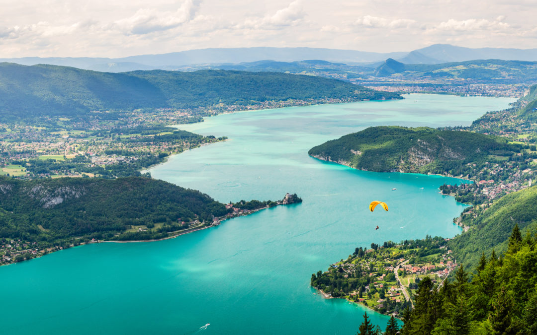
This loop is a must for every visitor to Annecy! It covers 40km and 300m of ascent. A large part of the tour is made up of cycle paths, including the famous " voie verte", one of the oldest in France. It's generally recommended to cycle clockwise, to get as close as possible to the water, but also so that the main climb from Menthon to Talloires is a gentle one. Most of the rest is flat... a real pleasure! The beauty of this tour is that you can discover all its wonders at your leisure. A swim in the turquoise waters of the lake, a picnic on the beach, a visit to the village of Talloires and its romantic bay, a stroll in the nature reserve at the end of the lake...
The tour can be done in 2 or 3 hours if you don't stop, but it would be a shame not to make the most of it. With no fewer than 9 communes bordering the lake, there's so much to discover! And for an enjoyable ride, remember to pack the right equipment: helmet, water, cell phone, extra clothing and waterproof jacket depending on the weather, sunglasses, sunscreen and swimsuit. The lake temperature fluctuates between 20 and 24°C in summer, so you'll have no trouble getting in the water!
Find the tour du lac itinerary on the Vélo Savoie Mont Blanc application and their website or in PDF format on theLake Annecy Tourist Office website: Lake Annecy greenway map.
AROUND THE LAKE
Because there's much more to Annecy than its lakeside tour, here are a few suggestions for exploring the surrounding area, and getting a little closer to the mountains. But first, you should know that the lakeside cycle path extends all the way to Albertville at Doussard! You can take advantage of this to visit the Seythenex grotto and waterfall, the donjon of the Lords of Faverges, the archaeological museum and the butterfly and insect museum.
Between Doussard and Faverges, many mountain bike trails are easy and accessible. The Sources du Lac Tourist Office lists a number of them on its "Mountain bike map", which you can download here: Source du Lac d'Annecy mountain bike map. Routes suitable for mountain bikes include La Favergie, La Petite boucle, Le chemin du facteur and Au fil de l'eau. The difference in altitude is slight, and it's an opportunity to pass through typical hamlets, skirt streams and get a little closer to nature! The track and details of these routes can also be found on the Vélo Savoie Mont Blanc app. All you have to do is let the smartphone navigation guide you.
Would you like to get some height? Whether you're a seasoned cyclist or an electric bike enthusiast, there are many routes that take you close to the mountains. The best known is the Col de la Forclaz, which takes you right up to the mythical summit of La Tournette. Several hiking loops are accessible from this pass. Another emblematic mountain is the Semnoz. With its 17km climb, you'll need strong legs - or a fully-charged electric bike! We advise you to spend the day here, as the views of Mont Blancare splendid, and you can enjoy traditional restaurants, farm cheese sales, summer tobogganing, hiking and more.
What will you choose?